.png)


Lake Como Greenway: My Complete Walking Guide


A practical guide to walking the Greenway del Lago di Como — including how to get there, the route from Colonno, my favourite stops and tips from my experience.
When you think about exploring Lake Como, chances are you imagine being out on the water.
And while there's certainly something special about cruising across one of Italy's most famous lakes, I wanted to discover whether there was another way to experience it.
One that didn't involve ferry timetables, expensive excursions or fighting for a seat on a crowded boat.
So I headed to the western shore to walk the Greenway del Lago di Como, an approximately 11-kilometre walking route through historic villages, narrow alleyways, beautiful waterfronts and some spectacular scenery.
And the best part? The walk itself is completely free.
Of course, you'll probably want to stop for a coffee, lunch or an ice cream along the way. And you'll need to get yourself to the starting point. But compared with many of Lake Como's other visitor experiences, it's a wonderfully accessible way to explore the region.
I walked the Greenway during the height of summer, discovering some lovely places to stop, a few confusing signposts and a side of Lake Como that you don't necessarily see from the water.
Here's everything I'd recommend knowing before setting off.
At a Glance
Location: Western shore of Lake Como, Italy
Route: Colonno to Griante
Distance: Approximately 11 km (published measurements vary)
Walking time: Around 3.5 hours without extended stops
Recommended time: Half a day or longer
Difficulty: Generally easy, with some steps and uphill sections
Cost: Free to walk
Starting point: Via Cappella / Via Luigi Civetta, Colonno
Getting there: Public bus or ferry services
Best time to visit: Spring and autumn for more comfortable walking temperatures
My experience: Walked from Colonno towards Tremezzo, finishing at Bar Mayer
My biggest tip: Don't rush the Greenway. The villages, waterfronts and unexpected discoveries are what make it such an enjoyable adventure.
Watch My Greenway del Lago di Como Adventure
What Is the Greenway del Lago di Como?
The Greenway del Lago di Como is a walking route along Lake Como's western shore, connecting Colonno, Sala Comacina, Ossuccio, Lenno, Mezzegra, Tremezzo and Griante.
Unlike a mountain hike, the Greenway isn't about reaching a summit.
It's about discovering the places along the way.
The route passes through narrow village streets, alongside waterfronts, past historic villas and churches, and up to viewpoints overlooking the lake.
Sections also follow the historic Strada Regina, an important route that once connected communities around Lake Como with areas further north.
That's one of the things I particularly enjoyed about the Greenway.
You're not simply walking beside Lake Como. You're walking through communities that have developed around it over centuries.
And occasionally, you discover something completely unexpected.
During my adventure, I found a house with what might be the best garage view I've ever seen, a bar overlooking tennis and padel courts, and wonderful views towards the only island on Lake Como.
It's these little discoveries that give the Greenway its character.
How to Get to the Greenway from Como

If you're staying in Como, you'll need to travel north along the western shore to reach Colonno, the traditional starting point of the walk.
The main options are bus, ferry or car.
I chose the bus, and despite a slightly frustrating start to the morning, it worked out rather well.
Taking the bus from Como to Colonno
I'd originally hoped to travel by ferry, but the service I wanted wasn't available when I tried to book.
It was a useful lesson about visiting Lake Como during the summer: popular ferry departures can become very busy, so don't leave your travel arrangements until the last minute.
Instead, I took the C110 bus from Como towards Colonno.
The journey took approximately 40 minutes and cost me €4 for a single ticket during my July 2026 visit.
I boarded at the bus station near Como Lago railway station, on the eastern side of the city centre.
For my journey, the bus was both quicker and cheaper than the ferry options I'd been considering.
Bus fares and timetables can change, so check the latest information rather than relying on the price I paid.
Official bus information: ASF Autolinee
My tip: Check whether two buses leave close together
When I travelled, two buses were scheduled to depart just a few minutes apart, followed by a much longer gap.
The first was extremely busy.
But the second was noticeably quieter.
I can't promise that will always happen, but if you notice two services running close together, it might be worth waiting for the second rather than joining the crowd for the first.
Sit on the right-hand side for the views

If you're travelling north from Como, try to get a seat on the right-hand side of the bus.
You'll be treated to some beautiful views across the lake as you make your way towards Colonno.
One final warning: public transport around Lake Como can become incredibly busy during the summer. Don't assume you'll always get a seat or that the journey will run exactly to schedule.
Can you take the ferry to the Greenway?
Yes, depending on the services operating and where you want to join the route.
Travelling by ferry can be a lovely way to explore Lake Como, but it isn't necessarily the most practical option for reaching the traditional Greenway starting point.
Colonno isn't one of the lake's main ferry hubs, and services can be limited.
The ferry journey from Como can also take considerably longer than the bus, depending on the route and stops.
I'd recommend comparing the current ferry timetable with the bus services before deciding how to travel.
If you're visiting during the busy summer months, book ahead where possible.
Official ferry information: Navigazione Laghi
Can you drive to the Greenway?
Yes, although parking is limited around the traditional starting point in Colonno.
If you're travelling by car, research parking before arriving and consider how you'll return to your vehicle if you plan to walk north towards Griante.
For anyone staying in Como, I think public transport is worth considering because you can finish the walk at a different village without needing to return to the starting point.
Where Does the Lake Como Greenway Start?

The traditional starting point is in Colonno, a small village on Lake Como's western shore.
And this is where I encountered my first navigation puzzle.
After getting off the bus, I spotted a sign directing walkers towards the Greenway down towards the waterfront.
However, the route instructions I was following suggested heading uphill instead.
I decided to follow those instructions.
Finding the route in Colonno
The traditional route begins along Via Cappella, climbing uphill before continuing towards Via Luigi Civetta and Colonno's historic centre.
Look out for the Greenway Panoramica sign directing you up Via Cappella — which is also where you can park if you driving to the start point.
After a short climb, I reached a Greenway information board, which confirmed I was on the intended route.
That was reassuring, particularly as I was still getting my bearings.
Sports Travel Tom Tip: Save the official Greenway route map on your phone before arriving in Colonno. The signs aren't always immediately obvious, and having the map available makes navigating the villages considerably easier.
Official route information: Greenway del Lago di Como
Walking the Lake Como Greenway: My Step-by-Step Guide
The Greenway is traditionally divided into sections connecting the villages along Lake Como's western shore.
One important thing to understand is that this isn't one continuous lakeside promenade.
The scenery changes throughout the walk, taking you through historic settlements, short uphill stretches, shaded alleyways, countryside and open viewpoints.
I followed the route north from Colonno towards Tremezzo, where I decided to finish rather than continue to the official end point in Griante.
Here's what I discovered along the way, followed by some information for anyone planning to complete the final section.
Stage 1: Colonno to Sala Comacina

The walk begins with a short climb through Colonno, passing its historic centre before continuing towards Sala Comacina.
The route crosses the Pessetta stream and joins sections of the ancient Strada Regina.
You'll encounter old stone buildings, narrow streets, terraced land and beautiful views over Lake Como.
One of the things I noticed almost immediately was how different this felt from the busy waterfront around Como.
It was quieter, more traditional and full of character.
There are some gentle uphill sections, but the views provide a lovely introduction to the walk.
And it wasn't long before I found myself stopping to admire some of the houses.
One property had a garage overlooking the lake. Quite possibly one of the best garage views I've ever seen.
It was a small discovery, but exactly the sort of little quirks I was hoping to find by exploring Lake Como on foot.
Stage 2: Sala Comacina to Ossuccio
Continuing north, the Greenway follows sections of the old Strada Regina through terraced countryside and small olive groves.
Along this stretch, you'll encounter the chapel of San Rocco.
There's also an optional detour towards the medieval centre of Sala Comacina for anyone wanting to explore further.
But one of the real highlights is the view across Lake Como towards Isola Comacina.

This is the only island on Lake Como, and it's a particularly beautiful sight surrounded by the water and mountains.
It was here that I began appreciating one of the biggest advantages of walking rather than travelling by boat.
You can stop whenever you like.
There's no timetable dictating when you need to move on.
If you find a particularly beautiful viewpoint, you can simply enjoy it.
And on a walk with scenery like this, that's a considerable advantage.
Stage 3: Ossuccio to Lenno
This was one of my favourite parts of the Greenway, partly because there were so many tempting places to stop.
Ossuccio: Lunch overlooking Lake Como
As you enter Ossuccio, the route passes through a mixture of historic streets and village surroundings.
Look out for the church of Santi Giacomo e Filippo and the distinctive Santa Maria Maddalena bell tower, two landmarks worth knowing about along this part of the walk.
I also noticed that the Greenway signs had changed appearance.
Earlier, I'd been following brown and white signs. Around this section, blue and yellow markers began appearing.
Another good reason to keep that route map handy.
By this point, I was ready for lunch. And I found a wonderful place to stop.
Baretto Ossuccio has a beautiful setting overlooking Lake Como.

The outdoor terrace looks across tennis and padel courts towards the lake beyond.
Sitting there enjoying lunch, with the mountains and water stretching out in front of me, was one of the most enjoyable moments of the adventure.
It's the sort of place I'd love to call my local.
And it's exactly why I wouldn't recommend rushing the Greenway.
You could walk straight through Ossuccio without stopping, but you'd be missing one of the pleasures of exploring Lake Como on foot.
Sports Travel Tom Tip: If you're planning to stop for lunch, Ossuccio is a lovely option. Baretto Ossuccio was one of my favourite discoveries, although it's worth checking opening hours before relying on it.
Villa Balbiano and the historic hamlet of Campo

Continuing along the route, you'll pass Villa Balbiano before reaching the historic hamlet of Campo.
This was another section I really enjoyed.
The Greenway takes you through narrow alleyways between old buildings, with occasional glimpses of the lake.
I remember spotting one house and thinking how extraordinary it must be to have Lake Como practically outside your front door.
There was also plenty of shade, which was particularly welcome on a hot July afternoon.
Navigation tip: After passing through Campo, I encountered a short section where the Greenway signs weren't immediately obvious.
On the route I followed, I walked uphill away from the water, and the signs soon reappeared.
Villa del Balbianello: Is the detour worth it?
As you approach Lenno, there's an opportunity to visit one of Lake Como's most famous villas.
If you've watched the James Bond film Casino Royale, you might recognise Villa del Balbianello.
The villa appeared in the 2006 film as the location where Bond recovers after his rather unpleasant encounter with Le Chiffre.
It's one of Lake Como's most recognisable attractions.
However, visiting requires a detour from the Greenway and separate admission arrangements.
When I visited, the queue was extremely long, so I decided to give it a miss and continue towards Lenno.
If visiting Villa del Balbianello is important to you, I'd recommend checking admission arrangements and booking requirements before travelling.
Allow additional time for the detour, and remember that it's an optional attraction rather than part of the Greenway itself.
You can also investigate boat transfer options from the Lenno waterfront.
Official visitor information: FAI – Villa del Balbianello
Lenno: A beautiful waterfront promenade

The Greenway eventually brings you down towards the lovely waterfront at Lenno.
And this is a place worth spending some time.
The promenade is lined with restaurants, cafés and opportunities to enjoy an ice cream, with boats coming and going across the lake.
This section of the route passes several historic landmarks, including the parish church of Santo Stefano and the Baptistery of San Giovanni Battista.
But what I enjoyed most was simply the atmosphere.
After walking through historic alleyways and countryside, it was lovely to be right beside the lake again.
You can sit beside the water, enjoy a drink or watch life unfold along the tree-lined promenade.
For me, Lenno was one of the highlights of the entire Greenway.
Stage 4: Lenno to Mezzegra
Leaving Lenno at the northern end of the promenade, the Greenway crosses the Pola stream and continues towards the waterfront near Hotel San Giorgio.
This was another highlight of my walk.
Although the Greenway follows the western shore of Lake Como, much of the route is set back from the water or slightly elevated.
Here, you're right beside the lake again.
There's a lovely stretch along the waterfront, with a small beach and a café nearby.
It provides another tempting place to stop.
And if you're visiting during the summer, you might want to pack your swimming gear for the opportunity to cool down in the lake, where swimming is permitted and conditions are safe.
The uphill climb towards Mezzegra
After leaving the waterfront, the route heads towards the main Strada Regina road again.
Cross carefully before beginning the climb uphill towards Mezzegra.
Now comes around ten minutes of uphill walking.
For me, this was one of the steepest and most demanding section of the Greenway.
And during the height of summer, I certainly felt it.
But the reward was another change of scenery.

Within minutes, the walk felt much more rural.
There were horses in the fields, open countryside and views of Lake Como below to my right as I travelled north.
It was a completely different experience from the cafés and waterfronts of Lenno.
And another reason I enjoyed the Greenway so much.
You never quite know what the next section will bring.
Stage 5: Mezzegra to Tremezzo
The Greenway continues through Mezzegra, passing historic buildings and several interesting landmarks.
The route follows Via Pola and Via Pola Vecchia before continuing towards the parish church of Sant'Abbondio.
The churchyard offers beautiful views across Lake Como and the surrounding area.
I remember enjoying a welcome breeze here after the climb.
It was another reminder of how demanding even a relatively straightforward walk can become during the summer.
Casa dei Presepi and Bonzanigo
From the church, the Greenway winds downhill past Casa dei Presepi.
It then continues past Palazzo Brentano and through the historic hamlet of Bonzanigo.
This was another section full of narrow streets and traditional buildings.
I wouldn't necessarily describe every village as a major attraction in its own right.
Rather, it's the combination of them that makes the Greenway so enjoyable.
You get a real sense of the communities and landscapes that exist between Lake Como's better-known tourist destinations.
Finishing my walk in Tremezzo
By the time I approached Tremezzo, the summer heat was beginning to take its toll.
I'd already enjoyed a wonderful collection of viewpoints, historic villages, waterfront stops and unexpected discoveries.
Rather than push on simply to say I'd completed the full distance, I decided Tremezzo would be a good place to finish.
I'd originally considered finishing at the Grand Hotel Tremezzo, but then discovered Bar Mayer, beside the lake in the Playa Tremezzina park.
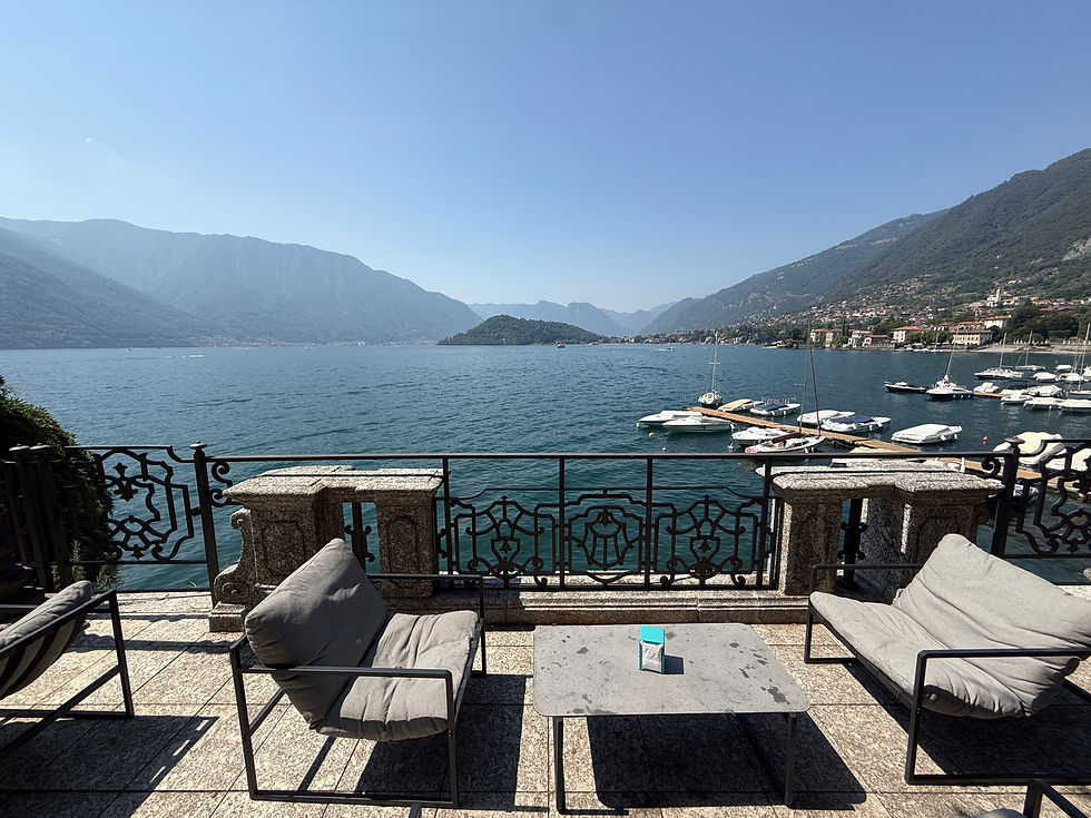
It was a lovely setting, and I decided it was the perfect place to end my Greenway adventure.
The ice-cold beer was particularly welcome.
And I think there's an important lesson here.
You don't necessarily have to walk every kilometre to enjoy what makes the Greenway special.
You can tailor the experience to your interests, available time and the conditions on the day.
Stage 6: Tremezzo to Griante
The official Greenway continues beyond Tremezzo towards Griante.
This final section is different from some of the earlier stages, with stretches closer to the lakeshore and the main road.
I didn't complete this final section during my filmed adventure, so I won't pretend to offer a first-hand review of it.
If you're planning to walk the entire Greenway, I'd recommend following the official route map for the final approach to Griante.
You can also use the public transport connections along the western shore to plan your return journey.
Official route: Greenway del Lago di Como
How Difficult Is the Lake Como Greenway?
Overall, I'd describe the Greenway as an accessible walk with some moderately demanding sections, rather than a difficult mountain hike.
Much of the route passes through villages, along paved paths and through relatively gentle terrain.
However, there are uphill stretches, cobbled paths, steps and places where you'll need to cross roads carefully.
You should still be comfortable walking for several hours if you're planning to complete the full route.
The biggest challenge during my visit wasn't the terrain.
It was the heat.
Walking around 11 kilometres in the height of an Italian summer is very different from covering the same distance on a cool spring morning.
Even relatively short climbs can become tiring when temperatures rise.
For reasonably active walkers, I think the Greenway is very manageable in suitable conditions. But I'd be cautious about describing it as effortless, particularly during July and August.
Five things I'd recommend knowing before walking the Greenway
1. Start early in summer. You'll avoid some of the strongest afternoon heat and potentially some of the busiest public transport.
2. Carry plenty of water. There are cafés and restaurants along the route, but don't rely entirely on finding one whenever you need it.
3. Wear comfortable walking shoes. The Greenway isn't a technical mountain hike, but you'll encounter steps, cobbles and some uneven surfaces.
4. Save the official route map. The signage is generally useful, but I encountered several places where the direction wasn't immediately obvious.
5. Allow time for stops. The villages, cafés and viewpoints are what make the Greenway special. Don't treat it as a race to the finish.
I'd also recommend checking the weather forecast before setting off, particularly during periods of extreme summer heat.
Is the Lake Como Greenway Suitable for Families?
For families who enjoy walking, the Greenway could be a lovely way to explore Lake Como.
There are villages to discover, interesting landmarks and plenty of opportunities to stop for food and drinks.
However, I wouldn't automatically describe the entire 11.2-kilometre route as an easy family outing.
That depends on the ages of your children, their walking experience and the weather.
The route includes steps, cobbled paths and uphill sections, making it unsuitable for most pushchairs.
For younger children, I'd consider choosing a shorter section rather than attempting the whole walk.
The waterfront areas around Lenno and the sections through the villages could make particularly enjoyable shorter outings, depending on your starting point.
Where Are the Best Places to Stop for Refreshments?
One of my favourite things about the Greenway was the freedom to stop whenever somewhere caught my attention.
These were the places that stood out during my walk.
Baretto Ossuccio: My favourite lunch discovery, with a terrace overlooking tennis and padel courts towards Lake Como.
Bar Lavedo area: A possible refreshment stop as you approach Lenno. I passed through without stopping.
Lenno waterfront: Plenty of cafés, restaurants and places to enjoy an ice cream. One of my favourite stretches of the walk.
Hotel San Giorgio waterfront: A lovely lakeside section with a small beach and a café nearby.
Bar Mayer, Tremezzo: The waterfront bar where I decided to finish my adventure with a very welcome cold drink.
Opening hours and availability can change, particularly outside the main tourist season, so check before planning your walk around a particular stop.
How to Get Back to Como After the Greenway
Thankfully, you don't have to walk all the way back to Colonno.
One of the advantages of the Greenway is that it passes through several communities with public transport connections.
Depending on where you finish, you may be able to return towards Como by bus or ferry.
I travelled back by bus.
And this is where I'd recommend allowing some flexibility.
During my visit, buses were busy, and I found the return journey less predictable than the outward trip.
I sometimes waited around 30 minutes, with delays making the timetable difficult to rely on.
On particularly busy services, buses may have limited room for additional passengers meaning they won't stop at times.
I'd recommend checking the latest ticketing arrangements before travelling, including whether you can buy tickets in advance or pay on board as well as avoiding tradional rush hour periods.
Don't assume you'll always be able to board the first bus that arrives.
The Greenway also passes near several ferry connections, although not every service stops at every village.
My advice: Work out your return options before starting the walk, particularly if you're planning to finish late in the afternoon.
Useful resources:
When Is the Best Time to Walk the Lake Como Greenway?
Based on my experience in July, I'd seriously consider walking the Greenway during spring or autumn.
The summer scenery is beautiful, but the combination of strong sunshine, high temperatures and busy public transport can make the day more demanding than expected.
Spring and autumn may offer more comfortable walking conditions, although the weather can still be variable.
If you're visiting during summer, I'd prioritise an early start, plenty of water and a flexible itinerary.
And remember that the Greenway is an outdoor route. Conditions can change, so check the weather and any current route notices before setting off.
Lake Como Greenway: Frequently Asked Questions
Is the Lake Como Greenway free?
Yes. The Greenway itself is completely free to walk. You'll still need to budget for transport, food, drinks and any paid attractions you choose to visit.
How long is the Lake Como Greenway?
The official route is approximately 11.2 kilometres, running between Colonno and Griante.
How long does the Greenway take to walk?
The route is commonly estimated at around three and a half hours of walking, but I'd allow at least half a day if you want to enjoy the villages, viewpoints and stopping points.
Where does the Lake Como Greenway start?
The traditional starting point is in Colonno, following Via Cappella uphill towards Via Luigi Civetta.
Can you walk the Greenway in either direction?
Yes. I followed the route north from Colonno, but you can also explore individual sections or walk in the opposite direction.
Do you need hiking boots for the Greenway?
Comfortable walking shoes with good grip should be suitable for many walkers in dry conditions. Take extra care on wet or slippery cobbled sections.
Can you visit Villa del Balbianello during the walk?
Yes, but it requires a detour from the main route. Check admission arrangements and allow additional time if you want to visit.
Do you need to complete the whole Greenway?
Not at all. You can enjoy individual sections, particularly if you're short on time or visiting during hot weather.
Is the Lake Como Greenway Worth It? My Final Thoughts

I travelled to Lake Como wondering whether exploring it on foot could really compete with the experience of travelling across the lake by boat.
And after walking through historic villages, discovering unexpected viewpoints, enjoying lunch overlooking the water and exploring beautiful waterfronts, I think the Greenway makes a very strong case for itself.
What I enjoyed most was the freedom.
You can stop when you want, spend time in places that catch your attention and discover corners of Lake Como that you might otherwise pass straight by.
There are a few practical challenges. The signposting isn't always completely obvious, some sections involve uphill walking and the summer heat can be hard work.
But those things didn't take away from what was a memorable adventure.
Would I recommend the Greenway to someone visiting Lake Como?
Absolutely, particularly if you enjoy exploring a destination at your own pace.
And the fact that the walk itself costs nothing makes it even more appealing.
For me, the Greenway isn't just a free alternative to taking a boat around Lake Como. It's a completely different way to experience the destination.
And that's what makes it worth doing.
I'll continue sharing sports travel guides, ticket tips and experiences from stadiums, arenas and sporting destinations around the world here on Sports Travel Tom.
You can also follow the journey on Instagram, YouTube and TikTok @sportstraveltom, where I share regular ticket updates, travel guides and sporting adventures to help you travel better for sport and adventure.

Comments